


connemara Diamond peak!

CABERMAT
User
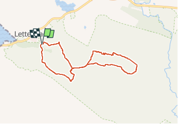

Length
6.9 km

Max alt
424 m

Uphill gradient
369 m
Km-Effort
11.8 km

Min alt
51 m

Downhill gradient
369 m
Boucle
Yes
Creation date :
2025-08-09 09:45:28.75
Updated on :
2025-08-09 18:05:10.586
2h20
Difficulty : Medium

FREE GPS app for hiking
 SityTrail
IGN / Geographical institutes
SityTrail Plus
The world is yours!
About
Trail Walking of 6.9 km to be discovered at Unknown, County Galway, Conamara Municipal District. This trail is proposed by CABERMAT.
Positioning
Country:
Ireland
Region :
Unknown
Department/Province :
County Galway
Municipality :
Conamara Municipal District
Location:
Ballynakill Electoral Division
Start:(Dec)
Start:(UTM)
437416 ; 5934008 (29U) N.
Comments